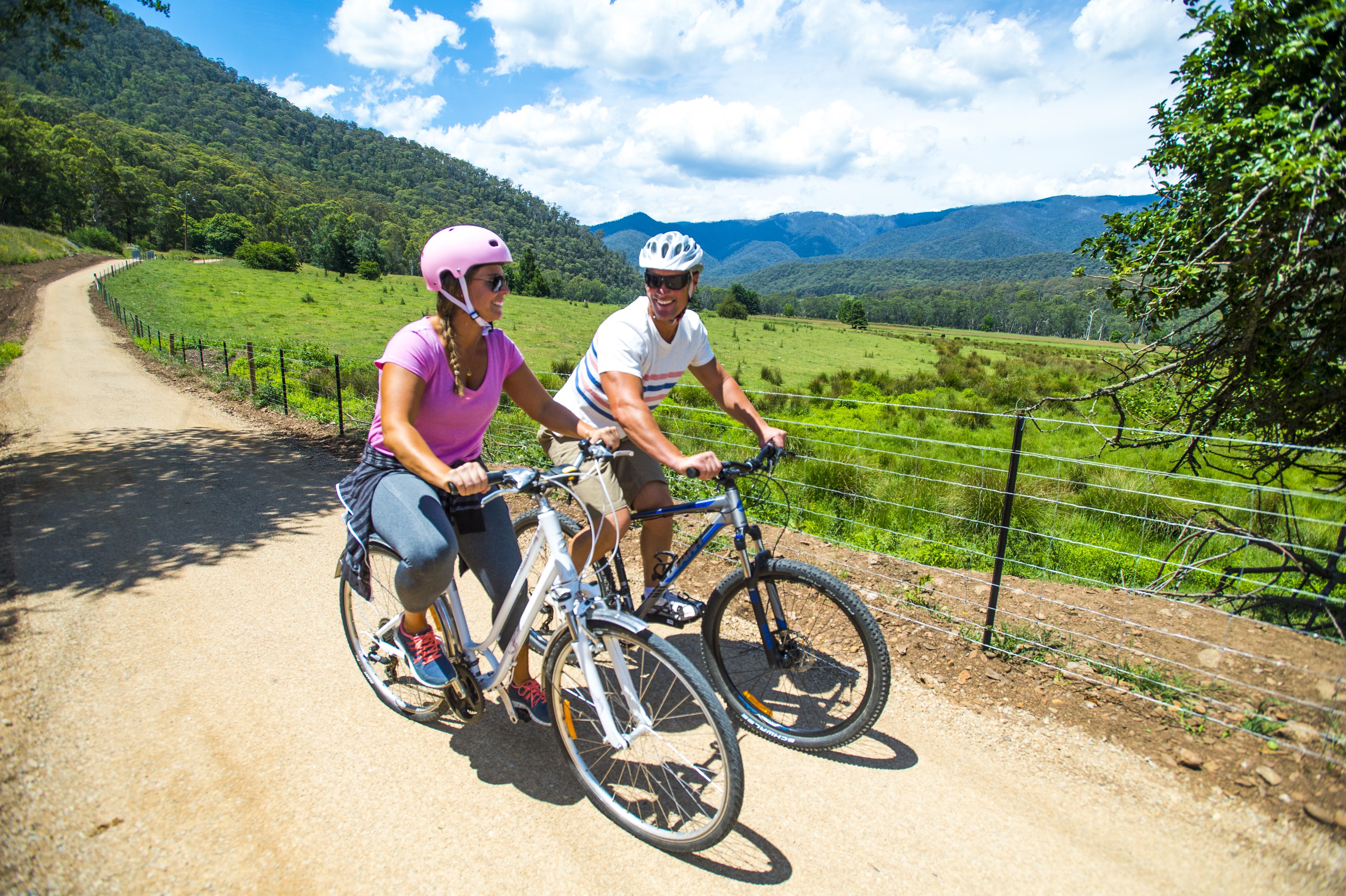
Great Valley Trail
The Great Valley Trail project will deliver 16 kilometres of family friendly shared trail, completing a 27 kilometre link between Harrietville and Bright, and extending the Murray to Mountains Rail Trail to the base of the Alps.
The trail will follow the Ovens River and the Great Alpine Road and will create an iconic national trail, significantly contributing to North East Victoria’s tourism economy.
Provide feedback on this project
Project Update - January 2022
The full length of the Great Valley Trail from Bright to Harrietville is now open and has been getting plenty of use over the holidays!
The trail is a 26km sealed, family friendly trail that connects Bright to Harrietville.
The final bridge near the Trout Farm has been opened and the asphalt finished.
Edge reinstatement, re-vegetation, and final clean up works will happen in coming months, weather permitting.
Thank you to all that have worked on the trail. This has been a large, complex project and wouldn't be where it is now without the continued support from the community, partner land managers and statutory authorities.
The head contractor on the project, North East Civil Construction, has worked hard through some extremely wet weather to get this project opened and we thank them for their efforts!
Project Update - Website | November 2021
Works are progressing well on the Great Valley Trail. The first layer of pavement is down and all major drainage work is complete.
Crews are working to install minor drainage, and to prepare the final pavement layer for asphalt works.
Three of the four bridges on the trail (Snowy Creek, Ovens River at Freeburgh and Smoko Creek bridges) will be in place during November. These bridges will not be open to the public until the concrete works associated with them have had time to cure (generally a couple of weeks).
We ask your assistance to please refrain from using them until they are opened. The fourth bridge (over Stony Creek) will be built during December.
The asphalt works began on November 22 and will continue for approximately 3 - 4 weeks, weather dependent.
With the assistance of a significant grant from Sustainability Victoria the entire surface of this section of the trail(16.7km) will be surfaced with an asphalt product which contains a significant amount of recycled content in the mix(rubber and glass).
The project demonstrates the circular economy at work - rubber and glass are diverted from landfill and used to improve the longevity and performance of infrastructure.
The project will utilise approximately 300 tonnes of recycled rubber and finely crushed glass that would otherwise end up in landfill, or as a pollutant in our natural environment and Alpine Shire Council is excited to be able to trial a high quality, more sustainable product.
To give the project the best chance of success, please ensure you follow all signage and refrain from using the path while it is under construction.
Asphalt works have begun from the Tawonga Gap end of the trail, and will make their way towards Harrietville over the coming weeks. Trail sections will be opened up for you to enjoy once they are completed.
Signs are currently in place, and we ask that people please stay off those sections of the trail until after the asphalt has been laid, and the area reopened for use.
Works will take 3-4 weeks to complete (weather dependent). Please follow signage instructions, even after working hours.
Signs are in place so crews can work safely, and so that surfaces can be prepared in advance of asphalt being laid.
If anyone walks or rides on the prepared surface, it needs to be re-worked prior to laying asphalt, causing delays.
Following asphalt works, there will be items such as signage to go in, bridge works to complete, fencing work and the install of road crossing treatments which will take us through December and into January, so we will continue to ask you to abide by the signage when it is in place.
When sections are safe they will be opened up for the community to enjoy.
Project Update | October 2021
Works are continuing on the Great Valley Trail.
It has been a wet winter and spring which has necessitated some changes to the program to ensure the project timeline stays on track, and at this stage the projected completion date remains unchanged at January 2022.
As a brief summary of works recently completed or underway in the near future:
- All significant culverts and earthmoving works for the trail are either complete or nearing completion.
- By the end of October we anticipate having all of the trail formation constructed, and a base layer of pavement.
- In November, three bridges will be constructed on site. This includes two pedestrian bridges at Freeburgh (which are steel bridges currently being fabricated off site) and one concrete bridge crossing Smoko Creek in Smoko.
- Also in November, minor drainage culvert works will be finalised, and the final pavement layer will be built and prepared for asphalt application.
- There will be one more bridge built in Harrietville in December (near the trout farm) - which is the final one required to link the trail up.
- Signage, crossing treatments, tidy up works etc. will commence in December and continue through to January.
- Round One of weed spraying (in areas of willow and blackberry removal) is underway. There will be another round in January, followed by planting of natives (tube stock) in April/May to select areas.
Alpine Shire Council and North East Civil Construction (the head contractor for the project) are working to open up areas for the public to enjoy once construction machinery is no longer working and the area is safe. When signage is in place, we continue to ask your assistance in keeping the work site safe by abiding by all signage, and keeping out of the areas until the construction of the section is complete.
Signage is only in place when required – we know people are keen for access into these areas and we are endeavoring to minimise the closure times, and open up these public spaces for you to enjoy as soon as we can. We expect the areas to get busier and busier over the next couple of months, and would please ask your continued assistance in staying out of the areas when requested so that we can build it as quickly as possible for you.
The November update (after Melbourne Cup weekend) will contain some detailed dates around programmed closures of sections to allow completion of final pavement preparation works and the asphalt application. Information about this will also be posted around the site(s) in the lead up.
Please contact customer service if you require any further information.
Project Update | September 2021
With the support of Traditional Owners and our project partners, works are continuing on the Great Valley Trail.
The projected completion date for this exciting project is January 2022.
The construction program has been adjusted slightly to allow works to continue during wet weather.
Pavement construction work cannot occur in the wet weather so works are mainly focused on construction of the basic formation of the trail.
- The guardrail is complete - this will form the physical barrier between the trail and the traffic lanes on the Great Alpine Road.
- Trail formation works are well underway on the northern half of the trail (maps 1-4)
- Trail formation works will continue on the southern section of the trail in September – McMahons Lane to the Trout Farm (maps 5-8)
- In October and November pavement works will be undertaken, generally working from map 1 – map 8 (north to south)
- Bridge site works will commence this month - there are four bridges on the Great Valley Trail, and an additional recreational bridge across the East Ovens River in Harrietville
- Trail sealing works is planned for December
- Weed spraying and re-vegetation work is continuing in previously blackberry and willow infested areas
We thank you again for your patience while this work continues, and remind you that the public are not permitted in the construction sites while construction work is undertaken.
Please assist in keeping the work site safe by abiding by all signage, and keeping out of the areas until the construction of the stage is complete.
We are endeavoring to minimise the closure times, and open up these public spaces for you to enjoy as soon as we can.
Project Update | July 2021
With the support of Traditional Owners and our project partners, works are commencing on the Great Valley Trail.
The (overall) project completion date is January 2022.
The project will be delivered in stages – the first stage will deliver a gravel path and the second stage will be to top up the path as required and apply an asphalt seal.
Stage 1 (the construction of the trail formation and the first gravel layer) is divided into eight sections as detailed below. This will deliver a gravel path which will be open for use for the public until the Stage 2 works are undertaken.
Public are not permitted in the construction sites whilst construction work is undertaken – we ask that you please assist in keeping the work site safe by abiding by all signage, and keeping out of the areas until the construction of the stage is complete. We are endeavoring to minimise the closure times, and open up these public spaces for you to enjoy as quickly as we can.
Stage 2 (the final gravel layer, and the asphalt seal) is programmed for November/December 2021. It is anticipated that it will take approximately two weeks to prepare the gravel base and asphalt each section (approx. 2km). More detail will be provided on the scheduling of this work as we approach the construction phase.
Each section will be closed during this time. Works timeframes are weather dependent.
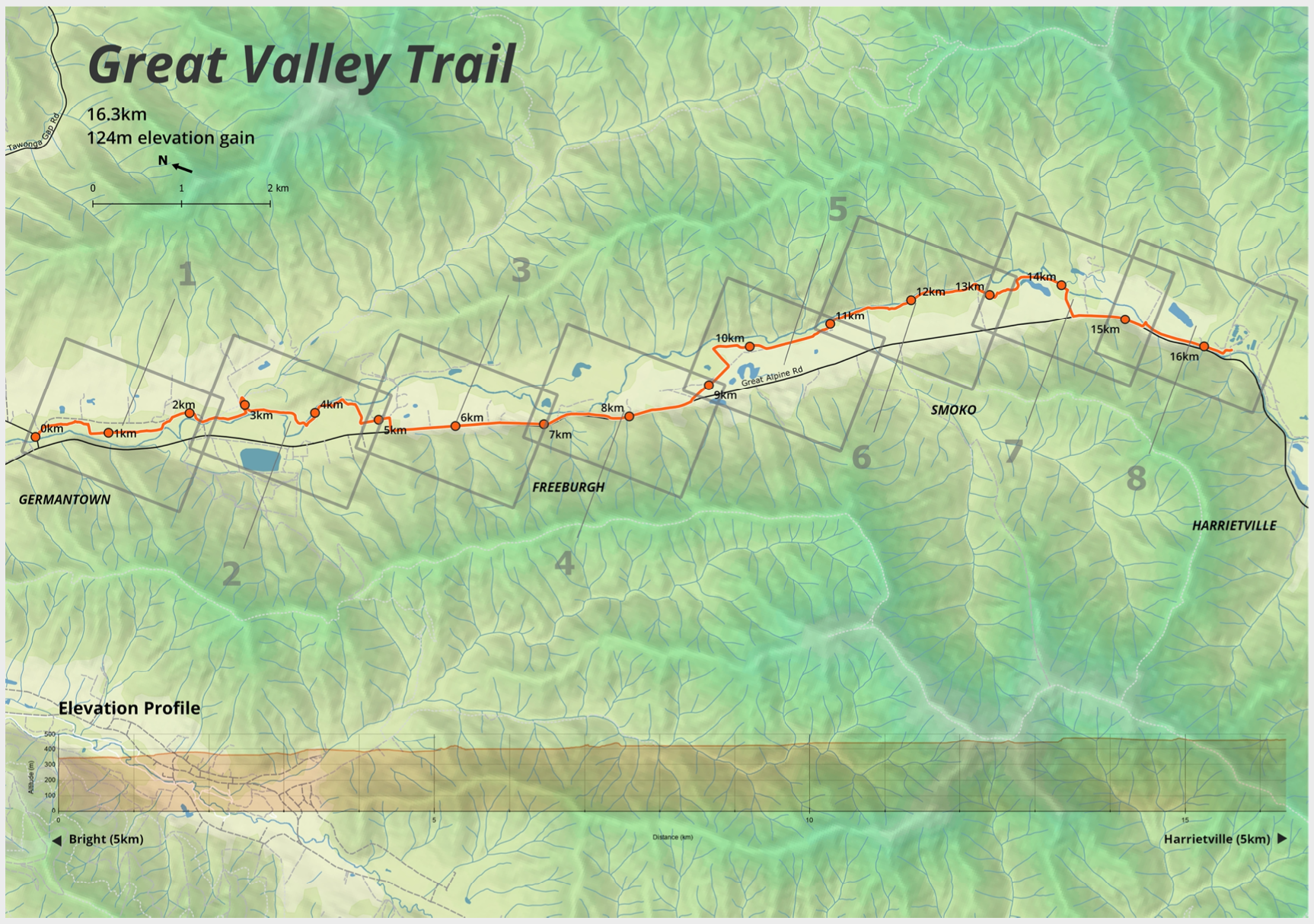
Section 1 - Germantown Streamside Reserve to Old Harrietville Road
Begins at the end of the existing trail at Tawonga Gap Road. The Great Valley Trail enters the Germantown Streamside Reserve and generally follows an access track for the full length (approx 2km). At the South end the trail crosses Old Harrietville Road, and stays on the East of the Ovens River. The track alignment through this section follows existing walking and vehicle tracks through the site. There is a parking area at the northern end, and the trail passes a picnic and bbq area at the southern (Old Harrietville Road) end.
Section 2 - Old Harrietville Road to Dibbin Lane
This section follows the Ovens River by reclaiming a section of forest previously inundated by blackberry and willow. The alignment follows a cleared power line easement for the first 300m, then leaves the power line easement and stays close to the Ovens river all the way to Snowy Creek. The trail crosses Snowy Creek, and follows an existing (informal) vehicle track all the way to the Ovens River – where a bridge will be built that crosses the Ovens River. From the Freeburgh township side (West) of the Ovens, the trail follows an existing vehicle track all the way to Dibbin Lane.
Section 3 - Dibbin Lane to Smoko
This section is on the Great Alpine Road Reserve. The trail is removed from the trafiic lane by 3 - 6m, but where it is close to traffic guardrail is being installed to ensure riders feel safe and protected. This section highlights the valley on the approach to the mountains – and gives views of Mount Hotham and the other alpine regions.
Section 4 - Smoko to McMahons Lane
Council has partnered with NECMA to undertake extensive woody weed reduction (blackberry and willow) through the Mills View area. The trail will be built around the remaining significant vegetation on the riverbank and through the river flats within the area. There is approximately 800m alongside the river, before approaching the Great Alpine Road through the significant stand of Poplars. Once on the Great Alpine Road, there is a section of approximately 1km (behind guardrail) until the trail joins McMahons Lane and leaves the Great Alpine Road.
Section 5 - McMahons Lane to Smoko Creek Road
The trail will be offset from the road on McMahons Lane for approximately 600m, and once the trail gets to the HVP pine plantation the Great Valley Trail will be constructed on the existing HVP perimeter road all the way to the end of the plantation. On the approach to the Smoko Streamside reserve the trail has pine plantation on one side, and native veg (and the Ovens River) on the other.
Section 6 - Smoko Creek Road to Smoko Campground
This section continues along the Ovens River, and crosses Smoko Creek as it connects to the Smoko Campground. The path crosses Miley Lane, and goes past the existing toilet block at the campground. The trail does not share the campground roads through this section.
Section 7 - Smoko Campground to Bibby Lane
The trail leaves the Smoko campground on an existing vehicle track, which will be closed to public vehicles and only open to shared trail users. Once the trail leaves the existing vehicle track, it enters ground which has recently reclaimed through blackberry and willow removal. The trail will meander through existing large trees along the river bank until it approaches a road reserve, where it makes its way back to the Great Alpine Road. There is 800m on the Great Alpine Road (again behind guardrail), before turning in at Bibby Lane to utilise the existing bridge to cross to the East side of the Ovens river.
Section 8 - Bibby Lane to Trout Farm
From Bibby Lane the trail follows the top of the Ovens riverbank all the way to Stony Creek. A new (shared) bridge will be built to cross Stony Creek, then the trail again separates from the road (Millers Track) and sits atop the Ovens Riverbank. The trail eventually breaks away from the Ovens, and meets up with the existing section of trail at the Harrietville Trout Farm (approx. 5km from Harrietville).
The total cost of the project is $2.6 million. $1.3 million is being contributed by the Federal Government through the National Stronger Regions Fund and $800,00 from Sports and Recreation Victoria, reducing Council’s commitment on this $2.6 million project to just $500,000.
The project will deliver the two metre wide trail and is due for completion by January 2022.
There has been strong and widespread community support for this project since an initial scoping study for the route was completed in 2011.
This trail will provide infrastructure that is accessible, free to use and safe, enabling all ages and socio-economic groups to participate in low impact exercise. The trail will also provide a connection between the Alpine Shire’s communities of Germantown, Freeburgh, Smoko and Harrietville.
The Upper Ovens River valley is a rich source of historical and cultural heritage and this trail will provide places for people to meet and interact, increasing community and social connection to each other and to the history of the valley.
The growth in ongoing economic activity will benefit existing businesses along the route, as well as stimulate the development of new businesses in Harrietville, broadening its appeal as a tourism destination and improving the resilience of the local tourism industry.


Rate this page
Visit Us
2 Churchill Avenue, Bright VIC 3741
Mon to Fri - 9:00am to 5:00pm
Contact Us
PO Box 139, Bright VIC 3741
03 5755 0555
TTY users phone 133 677
then ask for 03 5755 0555
All contact details and opening hours
Feedback
We would love to hear what you think about the website. Tell us by submitting the feedback form.